


Skály ČR
Description of Skály ČR
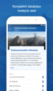
Skály ČR অ্যাপ্লিকেশন ব্যবহারকারীর কাছে চেক পর্বতারোহণ সমিতি দ্বারা নিবন্ধিত সমস্ত শিলা বস্তু এবং আরোহণ রুটের একটি সম্পূর্ণ ডাটাবেস উপলব্ধ করে, যার মধ্যে অস্থায়ী এবং স্থায়ী আরোহণের নিষেধাজ্ঞা সম্পর্কে স্পষ্টভাবে সংকেত তথ্য রয়েছে। Skály ČR অ্যাপ্লিকেশনের মাধ্যমে, আপনার পকেটে রিয়েল টাইমে বর্তমান এবং যাচাইকৃত তথ্য রয়েছে।
Skály CR অ্যাপ্লিকেশন অফার করে:
- চেক প্রজাতন্ত্রে আরোহণের শিলাগুলির একটি সম্পূর্ণ ডাটাবেস
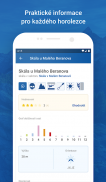
- মৌলিক পরামিতি, বর্ণনা এবং পৃথক শিলা এবং আরোহণের রুটের বৈশিষ্ট্য
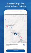
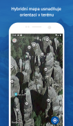
- মানচিত্রে পাথরের অবস্থান চিহ্নিত করা
- আজিমুথ দিক এবং দূরত্ব নির্দেশক সহ শিলাগুলিতে পৌঁছানোর জন্য নেভিগেশন
- শিলা এবং পথের জনপ্রিয়তার মূল্যায়ন
- আপনার নিজের ছবি যুক্ত করার সম্ভাবনা সহ প্রস্থান রুটের ফটো গ্যালারি
- ঘটনাস্থলে অ্যাপ্লিকেশন থেকে শিলার অনুপস্থিত অবস্থান লক্ষ্য এবং সম্পূর্ণ করার সম্ভাবনা
- ক্ষতিগ্রস্ত বীমা রিপোর্ট করার সম্ভাবনা
- পার্কিং স্পেস চিহ্নিত করা এবং পাবলিক ট্রান্সপোর্ট পাথরে থামানো
- নেভিগেশন অ্যাপ্লিকেশনের সাথে সংযোগ, যেমন Mapy.cz বা Google Maps
- অনুসন্ধান ফলাফল ডাটাবেস গঠন দ্বারা সাজানো
- ফটো সহ অফলাইন মোড
- অনুসন্ধান ইতিহাস
অফলাইন মোড!
অ্যাপ্লিকেশনটি অফলাইন মোডেও কাজ করে। আপনার কাছে দুর্বল বা কোন মোবাইল সিগন্যাল না থাকলে প্রয়োজনীয় এলাকা বা সেক্টর আপনার ফোনে পরবর্তী ব্যবহারের জন্য ডাউনলোড করা যেতে পারে (ফটো সহ)। এমনকি অফলাইন মোডেও, আপনি ডেটাতে পরিবর্তন, রেট, অবস্থান যোগ করতে বা নতুন ফটো যোগ করার পরামর্শ দিতে পারেন। নতুন ডেটা সারিবদ্ধ করা হয় এবং ডেটাবেসে স্থানান্তর করা হয় শুধুমাত্র যখন ফোনটি একটি সংকেতের সাথে সংযুক্ত থাকে।
ফটো, স্থানাঙ্ক এবং রুট বৈশিষ্ট্য যোগ করে, আপনি তথ্যের গুণমান উন্নত করেন যা সমগ্র আরোহণ সম্প্রদায়কে পরিবেশন করে। পর্বতারোহীদের জন্য পর্বতারোহী। আপনি সমর্থন পৃষ্ঠায় বিস্তারিত আবেদন নির্দেশাবলী, টিপস, কৌশল এবং প্রায়শই জিজ্ঞাসিত প্রশ্ন পেতে পারেন।
অ্যাপ্লিকেশন উন্নয়ন অব্যাহত. আরও উন্নত বৈশিষ্ট্য এবং উন্নতি কাজ করছে!
Skály ČR - Version 1.4.0
(04-04-2025)Skály ČR - APK Information
APK Version: 1.4.0Package: cz.horosvaz.skalyLatest Version of Skály ČR
Other versions


Apps in the same category

You may also like...


